An intense wildfire wreaked havoc in Lahaina, Maui, with the assistance of strong winds and dry weather conditions. Numerous buildings were impacted, and ongoing efforts for search and rescue were underway. Support is being provided by NASA’s Earth Applied Sciences Disasters program.
A rapidly spreading wildfire has caused extensive damage to the historical town of Lahaina situated on Maui, which is Hawaii’s second-largest island.
Satellite Image Analysis
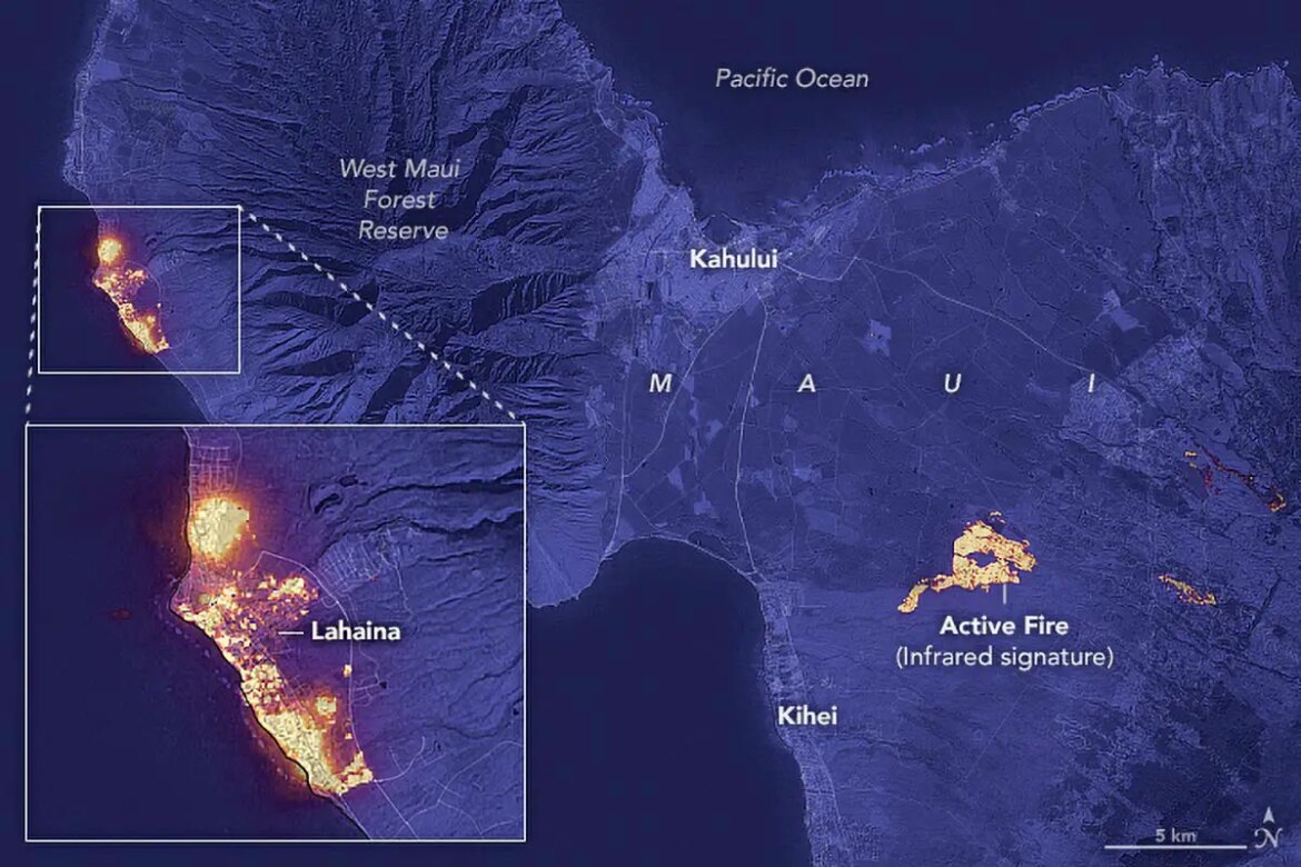
The provided image depicts the fire’s distinct pattern at 10:25 p.m. local time on August 8, 2023, captured by the Operational Land Imager (OLI) aboard Landsat 8. The image shows a considerable portion of Lahaina, a town housing around 13,000 residents, appearing to be engulfed in flames at the time of capture. Additionally, there was another significant fire to the northwest of Kihei.
This composite image is a result of the OLI’s recording of shortwave infrared light (band 6). Infrared data aids in identifying active fire locations, depicted in yellow on the image. The shortwave infrared data was superimposed on a natural-color mosaic image derived from Landsat 8 observations, enhancing geographical details.
Weather Conditions Leading to the Fires
The fires transpired amidst a period of forceful winds and arid circumstances in Maui. Between August 7 and 9, 2023, the island encountered peak wind gusts ranging from 45 to 67 miles per hour (72 to 107 kilometers per hour), according to the National Weather Service. The presence of a robust high-pressure system north of the island, coupled with Hurricane Dora to the south, likely contributed to the wind intensity. An analysis from the U.S. Drought Monitor indicated that the southwestern part of the island was grappling with moderate to severe drought when the fires erupted.
Reports of Damage and Search Efforts
Maui County documented damage to numerous structures, with particularly widespread destruction in the Lahaina harbor vicinity. Authorities were actively engaged in search and rescue operations on August 9.
NASA’s Assistance in Response
In response to the Hawaiian fires, NASA’s Earth Applied Sciences Disasters program has been activated. The program is actively offering support by sharing maps and data products on its publicly accessible mapping portal as new information becomes available.
Image credit: The provided image is created by Lauren Dauphin, utilizing Landsat data sourced from the U.S. Geological Survey.
Table of Contents
Frequently Asked Questions (FAQs) about Maui wildfire
What caused the wildfire in Lahaina, Maui?
The wildfire in Lahaina, Maui was caused by a combination of strong winds and dry weather conditions, which facilitated its rapid spread.
How was the wildfire’s impact captured?
The wildfire’s impact was captured through satellite imagery taken by the Operational Land Imager (OLI) on the Landsat 8 satellite. The imagery showed extensive areas of Lahaina engulfed in flames.
What were the weather conditions during the fires?
The fires occurred during a period of strong winds and dry weather in Maui. Peak wind gusts ranging from 45 to 67 miles per hour were recorded between August 7 and 9, 2023.
How did NASA support the situation?
NASA’s Earth Applied Sciences Disasters program provided support by actively engaging in the response to the wildfire. The program shared maps and data products on its open-access mapping portal to aid in understanding the situation.
What was the extent of the damage caused by the wildfire?
The wildfire caused damage to hundreds of structures in Maui, particularly in the Lahaina harbor area. Search and rescue operations were conducted to assist affected individuals.
What geographical area was affected by the fires?
The wildfire impacted Lahaina, a historical town on Maui, Hawaii’s second-largest island. The fire’s signature was visible in satellite imagery, showing the extent of the devastation.
Were there any contributing factors to the fires?
Yes, the presence of a strong high-pressure area north of the island and the influence of Hurricane Dora to the south contributed to the strong winds experienced during the fires. Additionally, the southwestern part of the island was facing moderate to severe drought conditions at the time, which likely contributed to the fire’s intensity.
What is the role of shortwave infrared data in the satellite image?
Shortwave infrared data is useful for identifying active fire locations, as it shows up as yellow in the satellite image. This data was overlaid on a natural-color mosaic image for better geographical context.
How did the fires impact the town of Lahaina?
The fires devastated the historic town of Lahaina on Maui, causing extensive damage to buildings and structures. The search and rescue operations were launched to provide assistance and support to affected residents.
Is there a specific date for the satellite image?
Yes, the satellite image was captured on August 8, 2023, at 10:25 p.m. local time. It provided a view of the wildfire’s impact on Lahaina during that time.
More about Maui wildfire
- Landsat 8 Satellite
- NASA Earth Applied Sciences Disasters Program
- National Weather Service
- U.S. Drought Monitor
- Lahaina, Maui
- Search and Rescue Operations
- Operational Land Imager (OLI)


4 comments
maui’s got hit bad, yo! wildfire, strong winds, boom! lahaina’s wrecked. nasa’s lendin a hand, good job!
hey, did ya see dat? wildfir takin ovr Maui! da sat pic’s crazzzy, lahaina’s like on fire n stuff. nasa’s helpin, cool!
omg, Maui’s burnin’! sat pic @ 10:25pm on Aug 8, 2023, shows lahaina town ablaze. weather went nuts wit strong winds, fires got wild. props to NASA 4 helpin out.
whoa, that pic’s insaneee! lahaina’s all fiery, man. nasa’s on it tho, supprt from them’s crucial rn. bad winds, dryness, real mess on Maui.