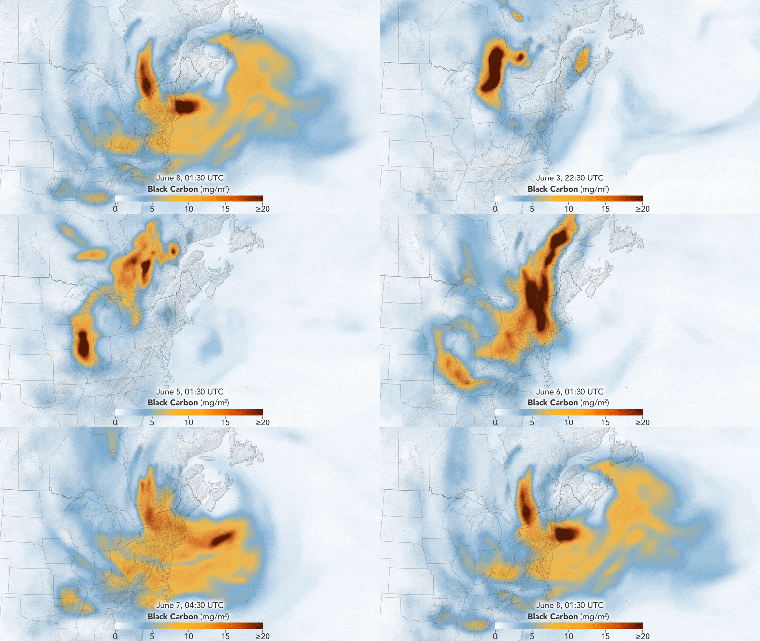
A series of potent wildfires blazing through Quebec have resulted in “dangerous” and “highly unhealthy” air conditions in the U.S. Northeast, leading to flight disruptions due to impaired visibility. Tracking data from NASA depict the movement of injurious black carbon particles, and the forecast indicates shifting winds could push the worst of the pollution further west.
Smoke stemming from the Canadian wildfires has led to unprecedentedly poor air quality.
On another day of some of the poorest air quality ever recorded in the region, the U.S. Northeast was affected by a significant increase in wildfire activity in Canada. Quebec disclosed 136 active fires on June 8, 2023, that have scorched an area roughly the size of Delaware.
The animated visual provides an understanding of how black carbon particles, also termed soot, migrated across the eastern sectors of Canada and the U.S. from June 3 to June 8, 2023. This pollution surge was triggered by an increase in wildfires in Quebec in early June. Following this, a weather system steered the smoke produced by these fires towards the northeastern and mid-Atlantic states, delivering hazardous air to these densely populated regions of the U.S.
The black carbon data is sourced from NASA’s GEOS forward processing (GEOS-FP) model, which integrates data from satellite, aircraft, and ground-based observation systems. The GEOS-FP model not only uses satellite observations of aerosols and fires but also includes meteorological data like air temperature, humidity, and wind direction to predict the behavior of the smoke plume. The fine particulate matter (PM2.5) within this pollution is tiny enough to penetrate the lungs and can lead to health issues.
On June 8, at 9 a.m. Eastern Time, air quality monitors in parts of Pennsylvania reported levels classified as “hazardous” (code maroon) on the EPA’s Air Quality Index (AQI) scale. Large cities such as New York City, Philadelphia, and Washington, D.C. recorded AQI levels in the “very unhealthy” range (code purple). The day before, an air quality monitor near Bethlehem, Pennsylvania, logged a 24-hour average AQI level of “hazardous”, an occurrence believed to be exceedingly rare in the area.
Besides posing serious health risks, the poor air quality and reduced visibility resulted in flight delays at major airports including New York City, Newark, and Philadelphia.
Persistent smoky conditions in the northeast and mid-Atlantic through June 8 may be driven further west due to changing wind patterns in the coming days, as per the National Weather Service.
NASA Earth Observatory video was produced by Lauren Dauphin, utilizing GEOS-5 data from the Global Modeling and Assimilation Office at NASA GSFC.
I agree to the use of Google Analytics and related cookies across the TrendMD network (widget, website, blog). Learn more
Yes No
Table of Contents
Frequently Asked Questions (FAQs) about Quebec Wildfires Air Quality Crisis
What caused the “hazardous” air quality levels in the U.S. Northeast?
The hazardous air quality in the U.S. Northeast was caused by severe wildfires in Quebec, Canada. These fires produced large amounts of smoke and soot, or black carbon particles, which were then transported by wind and weather systems to the U.S. Northeast, significantly degrading air quality in the region.
How have the Quebec wildfires affected air travel?
The Quebec wildfires have led to poor visibility due to smoke and haze, causing flight delays at major airports in the U.S. Northeast, such as New York City, Newark, and Philadelphia.
What does the NASA data show about the Quebec wildfires?
The NASA data, gathered from the GEOS forward processing (GEOS-FP) model, shows the movement of harmful black carbon particles, or soot, from the Quebec wildfires across eastern parts of Canada and the U.S. This model assimilates data from various sources, including satellites, aircraft, and ground-based observation systems.
What health risks are associated with the smoke from the Quebec wildfires?
The smoke from the Quebec wildfires contains fine particulate matter (PM2.5) small enough to enter the lungs, which can lead to various health problems. These particles can cause both short-term effects such as irritation of the eyes, nose, and throat, as well as more serious long-term effects like heart and lung diseases.
How are weather systems expected to affect the smoke pollution from the Quebec wildfires?
According to the National Weather Service, shifting winds are expected to push the worst of the pollution further west in the coming days. However, wind patterns can change rapidly, and the extent of their impact on the dispersion of smoke and pollutants will depend on various factors.
More about Quebec Wildfires Air Quality Crisis
- NASA’s GEOS forward processing (GEOS-FP) model
- EPA’s Air Quality Index (AQI)
- Health Risks of Wildfire Smoke
- The National Weather Service
- NASA Earth Observatory


